Boston’s Architectural Behemothology — UPDATED
February 5, 2013 § 3 Comments
 Government Center, downtown Boston. It is rare to see such a massive, overwhelming failure of this sort anywhere. Standing outside the T station last fall, I looked across the windswept brick City Hall Plaza, amazed that anyone ever thought this kind of brutalist behemethology was a good idea. Especially in a city like Boston that generally boasts beautiful architecture from the colonial era forward. Indeed, from Government Center, it’s just a few minutes’ walk to Faneuil Hall and the Old State House, or Beacon Hill, or the Common and Public Gardens. Boston’s public spaces are always full of people, tourists and Bostonians taking in the sights and the vibe. The city has even done a great job rehabilitating the old waterfront around Christopher Columbus Waterfront Park. Hell, even the park space over what was the Big Dig and the buried I-93 is used. But City Hall Plaza? There wasn’t a single soul on that desert of hideousness. Not a one. And, looking at this image, you can see why.

Government Center is, well, the centre of government in Boston, this perfect amalgam of city, county, and state government on one location. Government Center looms over downtown Boston like some horrible spaceship from the nightmares you have as a child. The New England Holocaust Memorial is just across Congress St. from Government Center. As I walked through the memorial, which is one of the most effective I’ve seen, I couldn’t help but feel the spectre of Government Center on me. Even as we walked on to Faneuil Hall, Government Center loomed above. It reminded me of that strange ball that followed No. 6 around in The Prisoner, keeping him from ever finding happiness or freedom.
Yes, Government Center is that bad. It sucks joy from the air around it. It stands as an insult against everything that surrounds it. It is, as a friend (an architect) would call it, an aesthetic insult. City Hall Plaza is bad, no doubt, but as that name indicates, there is a City Hall that comes with it. Boston’s City Hall is, not surprisingly, a horrible piece of brutalism, designed to intimidate the poor citizen standing outside of it. Every time I pass it, I imagine a cartoon of some poor, downtrodden sod standing in front of a faceless bureaucracy. Brutalist architecture is designed to be imposing and intimidating. And Boston is certainly not the only city to be marred by this abomination. University campuses are particularly good examples of brutalism, as I have noted elsewhere on this blog.
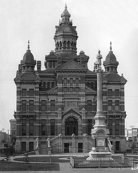 Winnipeg is a fine example of this. Its glorious initial City Hall, constructed in the late 19th century when Winnipeg was a boomtown, the laying of its cornerstone was a momentous occasion and a public holiday. Looking at the old building, it’s easy to see why Winnipeggers were so proud of it. It was a striking Victorian presence over the city. But, by the 1960s, it was antiquated and, like Boston, the ‘Peg choose to replace its City Hall with a new brutalist design.
However, unlike Boston, Winnipeg’s brutalist City Hall at least has greenspace around it. Interestingly, the introduction of greenery and foliage around brutalist architecture can go a long way to normalising it and reducing its imposition on the landscape. This is, I would think, why brutalist architecture on university campuses, as ugly as it is, doesn’t impose in the same way that Government Center does. Government Center is devoid of green space, there isn’t a single one anywhere on the massive, sprawling development. 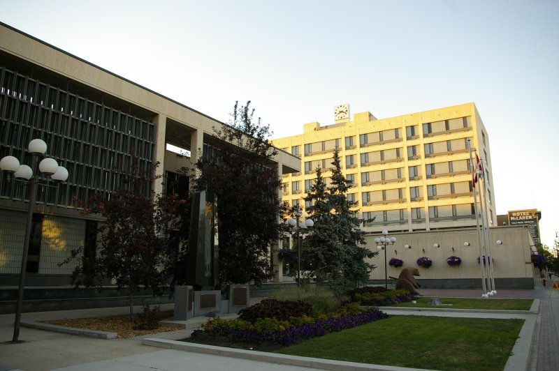
What Government Center replaced is Scollay Square, which was created officially in 1838, though the name dates back to the end of the 18th century; it was named for William Scollay, a local businessman. Scollay Square was the centre of downtown Boston throughout its existence. The problem was that by the Second World War, Scollay Square was getting seedy. One of its centrepieces was the Howard Theatre, and by this point, it was starting to slide downscale and attract a sleezy clientèle, mostly sailors on shore leave and, oh heavens!, students. Scollay Square was on the decline. And when the Howard was raided by the city’s vice squad in 1953 and shutdown due to a burlesque show, the writing was on the wall. The Howard eventually burned down in 1961. By the 1950s, Boston city officials were looking around for excuses to tear apart Scollay Square. The area was becoming home to too many flophouses and Boston’s rough waterfront had migrated too far inland. The Howard’s destruction by fire became the excuse to step into action, and it was torn down. Over 1,000 buildings were torn down and over 20,000 residents, most of whom were low income, were displaced.

In many ways, Boston is no different than any other North American (or, for that matter, European) city in the 1960s, undergoing urban redevelopment. Montréal also underwent massive redevelopment in the 1960s and 70s, as a trip through the downtown core shows today. Place-des-Arts, Place Desjardins, Place Ville-Marie, the Palais de Justice and the Palais de Congrès all date from this period. It’s not even the scale of Government Center that sets it apart from other redevelopment. No, it’s simply the massive failure of it, and its horrid imposition on the landscape of downtown Boston. Certainly, breaking up the monotony of concrete and red brick with trees, grass, and other such things would help. But, at the end of the day, as ugly as brutalist architecture is elsewhere, nothing can quite touch the size and grandeur of the buildings in Government Center. Walking up Staniford Street, it’s impossible not to be overwhelmed (or maybe the proper term is underwhelmed) by the Government Service Center.
Boston’s mayor, Thomas Mennino, has mused several times in recent years about doing away with at least City Hall and re-locating to South Boston. Not surprisingly, this was met with controversy, as a group called “Citizens for City Hall,” professing to love the building, threatened all kinds of hellfire and damnation should Mennino think about destroying it. Fortunately for them, the recession got in the mayor’s plans. Citizens City Hall sought to have the location designated as a landmark, and also noted that re-locating the seat of city government to Southie, as Mennino planned, would also lead to the dislocation of thousands of residents (again, just as when Government Center was built). At any rate, by 2011, cooler heads prevailed and a new group, “Friends of City Hall” sought to improve the present location and do something to make both City Hall and the Plaza more user friendly. Part of this work will begin this summer, when the MBTA shuts down the Government Center T station to remodel it. Hopefully something can be done to improve Government Center as a whole, not just City Hall and its Plaza, to make this abomination more user-friendly and more aesthetically appealing.
 UPDATE: From personal friend and Tweep, John P. Fahey. who grew up in New Haven, CT: Agreed, Government Center suffers in comparison with the architecture in the surrounding area. Urban Renewal was a hot button topic in the 1960s. The idea was to sweep out the old neighborhoods and replace them with new buildings. New Haven did the exact same thing in the 1960s as part of the Model Cities initiative. It knocked down a narrow swathe of a neighborhood that ran from where I-91 starts about 3 miles to Route 34. The City put up an ugly Coliseum that has since been knocked down. When I was a kid I used to ask my mother when they were going to finish it because it never looked complete. New Haven ran out of Urban Renewal money and thus there is this long narrow strip of land extending from the center of New Haven that resembles Dresden after the fire bombing. There was enough Model Cities money to knock down the old neighborhood but not enough to put up the new buildings. If the New Haven Veterans Memorial Coliseum was an example of the type of the architecture that the Elm City would have received, then maybe it was lucky.
Arrival Cities: The Book
December 10, 2012 § Leave a comment
I have touched on Doug Saunders’ Arrival City previously on this blog here and here. This review was also in the works with Current Intelligence before I left back in 2011. So, I am sticking it here for my own purposes.
Doug Saunders. Arrival City: The Final Migration and Our Next World. London: William Heinemann, 2010. ISBN: 9780307396891. 356pp.
Doug Saunders’ Arrival City was published to almost universal acclaim last fall. The Guardian nearly fell over itself hailing it as “the perfect antidote to the doom-laden determinism of the last popular book on urbanisation, Mike Davis’s Planet of Slums” and declaring it “the best popular book on cities since Jane Jacobs’s The Death and Life of Great American Cities half a century ago.” Saunders’ own newspaper, The Globe & Mail hails his calming certitude on the wonderful nature of progress that the city provides us. And the Wall Street Journal praises Arrival Cities for its optimistic view of globalisation.
Certainly, Arrival Cities is an important book, its well-written and is clearly and cogently argued. It is also somewhat of a disappointment, at least in the first half of the book. Saunders is the European Bureau Chief for The Globe & Mail and his reportage and columns generally provide a balanced view of the world; his is one of the few columns in that newspaper I actively seek out. Thus, I expected more from Arrival Cities. I did not get it. While Saunders does give us a counter-narrative to Davis’ doom and gloom, it occasionally reads Pollyana-ish. And at times, Saunders’ journalistic eye overwhelms his argument. Indeed, Dwight Garner in The New York Times notes this problem: his lengthy quotes from the people he talked to in arrival cities around the world sound formulaic and too easy.
Certainly, Planet of Slums was an overly statistical analysis, and statistics are on the aggregate level, they do not always us to view the micro- and quotidian levels. But Arrival City is plagued by the opposite problem: in focusing on a success story or two from each of the arrival cities he visits around the world (and Saunders has certainly been travelling the world), he over-personalises his arguments, which gives the impression that he’s choosing to extrapolate the success stories he saw, not the marginalised. Certainly, all of the people in arrival cities are marginalised in the larger sense of the word, but within the poor, there are class/caste divisions.
More fundamental, though, is Saunders’ reliance on Hernando de Soto’s arguments that all people need in the slums and favellas of the world is security of tenure, if they owned their own homes, all would be good. As Davis notes, the problem with titling in the slums is that it perpetuates the problem of class, in that the wealthier squatters win and the poorer lose, or continue to lose. And de Soto has also been criticised for over-estimating the amount of wealth land titling would create. The other problem of de Soto’s claims is the very notion of property: generally speaking, slums and favellas work due to the co-operation between residents. The creation of private property is at diametrical odds to this economic system. Saunders parrots de Soto throughout large part of Arrival City, arguing that private ownership of homes and security of tenure would encourage slum-dwellers to, essentially, take pride in their homes and communities and would give them a base of capital to invest in the economy. This is not to suggest that de Soto and Saunders are all wrong and their critics all right, but it is to suggest that life does not work quite as neatly and systematically as de Soto and Saunders would hope.
The first five chapters of the book are also plagued by an alarming ahistoricism as Saunders takes us on a tour of arrival cities across the globe from London to Dhaka, Nairobi, Los Angeles, and Shenzhen. In Chapter 5, he looks a the historical growth of cities in the west, focussing specifically on Paris, London, Toronto, and Chicago. Oddly enough, even in a historical chapter, one is left alarmed at Saunders’ ahistoricism. In discussing the differences between urbanisation rates in the United Kingdom and France in the mid-19th century, Saunders somehow manages to overlook the major impetus behind urbanisation in that century: the Industrial Revolution. The Industrial Revolution is the determinative factor behind the wildly different rates of urbanisation in France and Britain in the 19th century, plain and simple.
Also, a cardinal crime to an entire generation of historians, Saunders attempts to take on E.P. Thompson and The Making of the English Working Class. The problem is that he seems not to have read the book. He says that Thompson sees his working class heroes as “passive victims.” This is just plain wrong, the key argument that emerges from The Making is that the working classes were not just passive victims, that they employed agency in agitating for their rights through corresponding societies, proto-unions, and through the church.
In addition, one is left rather flummoxed by Saunders’ apparent naïveté in looking at housing projects in Paris. He criticises the project builders for not soliciting input from those who were to be the future residents of the projects. Seriously. Nonetheless, he does make the point that the lack of accountability on the part of both the authorities and residents in the projects, to say nothing of their discombobulating impact on community.
Following this, however, Arrival City improves exponentially, in the final five chapters. In this sense, it is as if the book is split in two. In the second half of the book, Saunders seems to adopt a more complicated approach to the arrival cities of the world. This includes pointing out the ridiculousness of immigration policies in Canada and the United States. Canada and the United States take in the largest number of immigrants in the world, at least on a per capita basis for Canada, a relatively tiny (population-wise) country.
But it is Saunders’ chapter on the geçekondus that surround Istanbul that really shines. Here, we get a detailed, excellent study of the politics of the geçekondus from the 1970s to today and the struggle of the resident of the slums to attain regularisation and integration into Istanbul. Istanbul, of course, is one of the fastest growing cities in the world. In 1950, Istanbul’s population was 983,000; today, over 13,000,000 call the city home. The slums on the Asian side of the Bosporus grew up in the 70s as impoverished rural Turks migrated to the great city. They established their slum housing outside the boundaries of the city and then agitated for the right to have such luxuries as running water and sewers. The organisers of the 70s and 80s were almost all radical lefties and, during the military dictatorship and its aftermath in Turkey, many spent time in jail and saw their homes routinely torn down. By the turn of the millennium, their geçekondus had been integrated into Istanbul (a large part of what saw the city’s population triple in the past thirty years). Today, these old geçekondus are now part of the inner ring of Istanbul suburbs, fully integrated into the city, and the children of these old radicals are Istanbullus. However, the geçekondus aren’t simply a case of de Soto’s economic theories being put into practice, the regularisation of the geçekondus and their residents, the geçekondullus, required state assistance.
In the second half of the book, Saunders also goes beyond the role of banks and business in the regularisation of the arrival cities. He also notes that the state needs to take an activist role, whether of its own accord or spurred on by the arrival city residents. In order to do this, however, the state needs to have the resources to do so. This is simply not possible in many impoverished and/or corrupt developing world nations, like Bangladesh. Instead, it requires the intervention of richer nations like Turkey, which could afford for Istanbul to absorb and regularise its geçekondus. But more than this, the integration and regularisation of these arrival cities is necessary for local schools, jobs, health care facilities, water and sewer services, and transportation. And then, finally, Saunders strikes a balance between the de Soto right and the Davis left:
What comes from this work, and form the experiences of families like the Magalhãeses in Brazil and the Parabs in India, is a conclusion that is unlikely to please the ideologues on the socialist left or the free-market right: to achieve social mobility and a way into the middle class for the rural-migrant poor, you need to have both a free market in widely held private property and a strong assertive government willing to spend heavily on this transition. When both are present, change will happen [p. 288].
What we are left with then, is half a great book. The first half of Arrival City is done in by its overly simplistic and journalistic approach, its lack of historicity and its over-reliance on de Soto. In the second half, though, Saunders finds his feet, and finds his own original argument that more than splits the difference between de Soto and Davis. I remain unconvinced that the urbanisation of humanity on such a level as we are seeing today is a good thing, but it is also a truism throughout history, at least in the West, that periods of urbanisation have spurred on trade, the economy, and general human progress. And during periods of de-urbanisation, such as in the Dark Ages following the fall of the Roman Empire in the West, Europeans were only slightly more evolved than cavemen, at least in relation to the rest of the Mediterranean world and the Middle East, as David Levewing Lewis points out in God’s Crucible: Islam and the Making of Europe, 579-1215. Either way, there is no simple answer to the question of the massive urbanisation of the globe today, despite what the Mike Davises and Doug Saunderses of the world would have us believe.
The Uniqueness of Cities
June 20, 2012 § 1 Comment
For some odd reason, I find myself reading a lot about London these days. I’m really not sure why, I have no real love for the city, to me, as represented in pop culture, it’s a megalopolis of bad architecture. Nonetheless, I am fascinated by authors’ attempts to tease out what it is that makes London a unique location. For the most part, I am reading cultural histories, so the focus is less on the built landscape of London (though that certainly frames the action) than on the people who live(d) there. For the most part, Londoners tend to be praised for their resourcefulness. And their stolidity. And the city itself for the ways in which it constantly re-invents itself.
I live in Montréal, a city that claims to be a unique location itself: a French-speaking metropolis in the Anglo sea of North America (conveniently, the Hispanic fact of the southern part of the continent always gets overlooked). Montréal is a bit of Europe in North America, I am constantly told by both the natives and the tourists who come here. When I lived in Vancouver, it was the outdoorsiness of the people that made the city unique (nevermind the fact that most Vancouverites AREN’T the outdoorsy types at all). And Doug Coupland argued it was the glass architecture.
I could go on, taking a trip around the world, laying out urban stereotypes as to what makes each unique. But in reading all this ephemera about London, I am continually struck by the fact that the things that apparently make London unique in the eyes of erudite and knowledgeable authors really just make London another generic big city. I would think that ALL urbanites are resourceful and stolid. And ALL cities constantly reinvent themselves. (As a running series on this blog about my neighbourhood of Pointe-Saint-Charles makes clear).
So what then? Cities are indeed generic. They all contain the same basics, which vary according to size. When it comes to the built environment, you’ve got a downtown core, inner-city residential neighbourhoods, some industrial (or post-industrial) inner city neighbourhoods, and these patterns repeat themselves out to and through the suburbs, residential/industrial, until you get to the city limits and the countryside takes over. Urbanites are a shifty breed, skilled at not noticing the homeless dude begging for change, but very skilled at noticing the various challenges along the sidewalk, including how to carefully avoid the homeless guy. Neighbourhoods in cities all follow similar patterns, there are points of convergence for the residents, there are amenities, parks, and so on.
And, of course, there is the anonymity of city life. I live in a city of around 4 million people, but I can go days, weeks, even months without running into someone I know on the streets of Montréal. I seriously doubt that is any different in Dublin, Boston, San Francisco, Nairobi, Tokyo, or Beijing.
So what is it that makes cities unique? What is it that makes London or Montréal unique? Does it come down to how we, the urbanites ourselves, choose to build our cities, and reinvent our cities, and carry out our lives in them? Certainly Pittsburgh has different things to offer than, say, Winnipeg. But either way, trying to boil down the lived experience of millions of people, and their millions upon millions of ancestors in any one urban location, whether it has existed for over 2000 years like London or for just over 200 years like Vancouver, is a pointless exercise. London is no more unique for its constant reinventions and the resourcefulness and stolidity of its people than is, I don’t know, St. Petersburg, Russia.
Adding to the Wasteland of Griffintown
April 13, 2012 § 1 Comment
I have taken to going through Griffintown on my morning run of late, in part because it gives me a chance to keep an eye on the redevelopment there. I come up from the Lachine Canal to de la Montagne, to Ottawa, over to Peel and then down Wellington back down to the Canal, which gives me a quick tour through the heart of old Griffintown, past the old ruins of St. Ann’s Church, by the recently sold Horse Palace, past the Merciers’ old home and Fire Station No. 3.
A condo tower is going up at the corner of de la Montagne and Ottawa, there is work going on around the Horse Palace, there is a new condo bloc at the corner of Ottawa and Murray. And another development is underway on the northeastern corner of Peel and Wellington. And then, of course, across Wellington, between Young and Shannon is Devimco’s massive construction site. Buildings have come down and holes have been dug for Devimco.

And Devimco has moved its condo sales office. It was once located up the block on the eastern side of Peel near Ottawa, but now it sits proudly, if not somewhat barrenly, on the southeastern corner of Peel and Wellington. I did find myself wondering if the sales people are still promising potential buyers that the CNR would move its railway, as the viaduct is across the very narrow Smith street from the site of Devimco’s condo towers.

At any rate, the old sales office is now just another wasteland on Griffintown’s landscape, yet another lot of urban refuse, but this time created by the very company which proposes to rejuvenate and renovate the Griff. Ironic, I thought.
Constructing Landscapes
February 8, 2012 § 1 Comment
[note: I originally wrote this article nearly 4 years ago for a site that no longer exists; as the ideas contained in this piece are still of interest to me, I am re-publishing it now, mostly for my own purposes going forward. I have updated parts of this article that were dated.]
I read a fascinating post at Geoff Manaugh’s BLDG Blog about a new video game from LucasArts that allows the player to modify the game’s battlespace through various (fictive?) technologies. And while that in an of itself is interesting, what struck me most was Manaugh’s reference to historian David Blackbourn’s book, The Conquest of Nature: Water, Landscape, and the Making of Modern Germany.

Frederick the Great, King of Prussia, 1740-86
Blackbourn argues that modern Prussia (a pre-cursor state to today’s Germany) was literally “made,” or at least its coastline was, during the reign of the Frederick the Great, who ruled Prussia from 1740-86. During this period, dykes were built, bogs and marshes were drained, land along the shoreline was created, moulded, and so on. Vegetation was imported and shifted from one locale to another along Prussia’s coastline. Frederick’s imperial projects in Prussia were not, in fact, unlike the works the Dutch did along their coastline to make the Netherlands both more productive and more liveable.
Blackbourn’s argument is an interesting one, to be sure: that modern Prussia (and therefore, today’s Germany) was literally made in the shape that Frederick desired; the land was sculpted. This was done not to give him more land to rule over, as Manaugh suggests, but to increase Prussia’s wealth. In the pre-Adam Smith era, the wealth of nations was measured in agricultural production. Indeed, this was a pretty common Enlightenment argument, popularised by François Quesnay and his colleagues in France, the Physiocrats.
Frederick was keenly interested in Enlightenment theories, and corresponded with many leading thinkers of the era. He even hosted the idiosyncratic French thinker Voltaire at his palace at Sans Souci for a while, until their particular personalities led to conflict. Adam Smith, for his part, was a colleague and correspondent of Quesnay and the Physiocrats, and developed his own theories on the wealth of nations, in part from this correspondence.
What’s of interest here is Blackbourn’s argument. Germany isn’t the only nation to be literally made from the ground up. All modern, industrialised, militarised Western nations are so-made. Many former colonial territories, such as India, Pakistan, and Bangladesh, also fall into this category. Our landscape is, all around us, “made”, both in the physical and intellectual sense. Our landscape is only as it is because we – as a culture, a society, as individuals – see it in a certain way.
 More than this, the landscapes of these industrialised, Western nations (and their former colonies) are man-made in many ways. Germany and the Netherlands are but two examples. England, also, is crisscrossed by canals, constructed by re-shaping the landscape of the nation to transport goods and commodities during its Industrial Revolution. Indeed, England is a good example of the forging, or of a landscape, as it has been largely deforested in order to create the fuel for industrialisation, and the landscape for industrialisation.
There’s more. All countries are made, or manufactured, in the sense Blackbourn means. In some cases, this is a natural phenomenon, such as the erosion of sea shores and river banks and coastlinesIn others, it’s man-made. Take, for example, the Gulf Coast of the United States and, in particular, New Orleans. We saw how much of that coast was devastated by Hurricane Katrina in 2005. While the hurricane was devastating enough, what failed in the case of New Orleans were man-made defences around the city, located as it is on the delta of the Mississippi River, and on the shores of Lac Pontchartrain.

New Orleans after Katrina
Close to 49% of the New Orleans’s geographic footprint is below sea level, and large parts of the city are sinking. New Orleans averages out at 0.5 metres below sea level, with some parts reaching 5 metres below sea level; but the city has been made a viable location for settlement, industrialisation, and economic activity due to mitigating works being built on the Mississippi and Lac Pontchartrain. All of this economic and industrial activity in New Orleans and along the Gulf Coast has also meant the destruction of nearly 5,000 square kilometres of coastline in Louisiana alone in the twentieth century, including many off-shore islands, all of which used to protect New Orleans and the Mississippi delta.
Thus, when Katrina hit 6 ½ years ago, on 28 August 2005, there were few natural defences left to protect New Orleans. The man-made “improvements” to New Orleans and the surrounding area were simply insufficient to deal with a hurricane the force of Katrina, which was classified as a Class 1 or 2 storm. The result was nearly 80 per cent of the city was flooded out, as well as massive social and economic dislocation. Today, New Orleans’s population is still only 60 per cent what it was prior to Katrina.
Getting back to Blackbourn’s argument: his arguments vis-à-vis the creation of modern Prussia can be transported across and around the industrialised Western world. Montréal (the population of Montréal’s metropolitan area is nearly four times the size of that of New Orleans), is the beneficiary of similar modern landscape engineering. The city is located on an island in the middle of the Saint-Lawrence River, and in a cold, northern climate. In the nineteenth century, each spring, during the spring run-off and thawing of the river, the low-lying portions of the city, located near the river bank on the flood plain, were swamped with water.

1886 Flood, Chaboillez Square, Griffintown, Montréal
In 1886, flood waters were over 3 metres deep. The flood led to mitigating works being constructed along the river, the bank was re-landscaped and engineered, dyking was constructed, and so on, all in order to prevent further flooding. This allowed Montréal’s industrial development to continue throughout the late nineteenth and early twentieth century . This allowed it go through an unprecedented growth cycle that only ended with the Depression of the 1930s, and enabled Montréal to solidify its position as Canada’s metropole (a role it has since lost to Toronto).
This re-shaping of the environment, however, is not limited to the West. More recently, the insta-city of Dubai in the United Arab Emirates has followed suit. Dubai itself is a manufactured landscape, as all cities are to a degree, but in the case of Dubai, the landscape has been purposely re-appropriated for the construction of the city. A more specific example can be seen in the city’s golf courses, for example, the Tiger Woods Dubai golf resort and residences. Golf courses are, in fact, a perfect example of the re-engineering of the landscape, as grass and various other features such as sand traps and water hazards – to say nothing of surrounding vegetation – are imported and planted into foreign
The construction and maintenance (such as irrigation and pesticides) of Dubai’s golf courses, situated as they are in the desert, present us with a massive redevelopment of the landscape, the environmental consequences of which appear to be lost on Woods and his partners in the project. Dubai City itself is an example of environmental re-landscaping for human needs and settlement. Without the sorts of technologies created by the Dutch and the Prussians (to say nothing of the English, Americans, and Canadians), Dubai itself would not exist in its present, insta-city form.
Phoenix, British Columbia: Ghost Town Reclaimed by Nature
February 5, 2012 § 14 Comments
Continuing in the vein of the Hawley Town Commons in Western Massachusetts and the changing rural landscape of Saint-Sylvestre, Québec, I present now to you the ghost town of Phoenix, British Columbia. Phoenix is located in the Kootenay Mountains of eastern BC, not far north of the American border.

Phoenix, BC, 1912
About a century ago, Phoenix was a thriving copper mining town. It boasted modern amenities such as electricity and phone lines, there was a ballroom and an opera house. it had a stop on the stage lines that ran through the Boundary Region of the Kootenays, there was a post office and around 1900, both the Canadian Pacific Railway and the Great Northern Railway arrived in Phoenix. In short, the town had made it. It was thriving. But as was often the case in the mining regions of the North American west, the boom years were short. At the end of the First World War, the price of copper dropped dramatically and the Phoenix Mine was shut down. And the town of Phoenix died.

Phoenix First World War Cenotaph, 1937
In the 1920s, the homes and buildings were torn down or buried and there was nothing left of Phoenix, except for its First World War cenotaph, which is still there today. Otherwise, nature has reclaimed the old town site of Phoenix, despite the operation of an open-pit mine in the 1950s, 60s, and 70s. When I visited Phoenix about 15 years ago, I was floored by the site. I had seen other ghost towns in BC, most notably Barkerville, a tourist site. But many other sites I had seen were maintained to at least some degree. Phoenix was a smallish clearing in the dense forest, and the forest was rapidly moving back in, re-claiming its territory. The grave yard was the most fascinating location on the old Phoenix townsite. Most of the head stones were long gone. Many of the graves no doubt never had a proper head stone in the first place, graves marked by wooden crosses, wooden heads, or whatever was handy. One grave, otherwise unmarked, had a furniture cabinet as a marker.
But otherwise, the grave yard had 80 year old pine trees reclaiming their territory, encouraged by the heavy fertiliser in the soil in the form of decomposing human bodies. (Since my visit, residents of nearby towns have sought to restore the graveyard some, restoring the headstones that do exist). What struck me the most about standing in the Phoenix cemetery, though, was not so much the dilapidated headstones, the cenotaph in the distance, or the trees. It was the black bear about 500 metres away, happily munching away on some berries. It was also the bear that convinced us to get back in the car, slowly and quietly, and get the hell out of there.
Rural Palimpsests; Or, the Changing Rural Landscape
February 3, 2012 § 9 Comments

Drawing of the Old Hawley Town Commons
About 18 months ago, I wrote this piece about the old Town Commons in Hawley, Massachusetts. I was struck by the history of what could no longer be seen in Hawley at the Town Commons where, in the mid-19th century, there was a vibrant townsite. Hawley also stirred up my own memories of having lived in a ghost town as a teenager, on the old town site of Ioco, British Columbia, now a part of Port Moody, BC. But Ioco, which will eventually become condos, I’m sure, was a (sub)urban townsite. Hawley is a town a few miles west of the Middle of Nowhere.
 In urban centres, we see the ruins of past civilisations all around us, whether they are palimpsests of old advertisements on the sides of buildings, or the ruins of buildings, still dotting the landscape. Indeed, I wrote my doctoral dissertation and a book on a neighbourhood that was, at least when I started writing, a ruin: Griffintown, Montréal. A decade ago, the landscape of Griffintown was an urban ruin, the foundations of the old Irish-Catholic Church, St. Ann’s, poking through the grass of Parc St. Ann/Griffintown; the rectory of the French Catholic Church, Ste-Hélène still stands, but the church is long gone, just a few corner stones and the remains of an iron fence are left. But this is a city, and cities, we are constantly reminded by scholars, poets, novelists, film-makers, etc., are living organisms, built to be rebuilt, constantly evolving and changing. By definition, then, the rural landscape is unchanging and constant.
Don’t believe me? Spend a bit of time reading literature set in the countryside. Or watch movies. Read poems. The landscape of the country side is eternal and unchanging. Entire nations have been built on the mythology of the countryside (I’m looking at you, Ireland!). Here in Québec, Maria Chapdelaine, a major novel of the early 20th century nationalist school explicitly tied the virtue of the nation to the land. The anti-modernists of a century ago celebrated the unchanging “natural” landscape of the countryside as a tonic for the frayed nerves of modern man. In Canada, the Group of Seven built their entire careers/legends on representing Ontario’s mid-North back to us as the nation. Watch a Molson Canadian ad these days, and you’ll learn that Canada has more square miles of “awesomeness” than any other country on Earth. And all that awesomeness is somewhere in the wheat fields of Saskatchewan. But the rural landscape DOES change and evolve, as the Old Hawley Town Commons will tell you.

This is where Robert Corrigan was fatally beaten on 17 October 1855
This was brought all the closer to me in late November, when I travelled out to Saint-Sylvestre, Québec, which is located about 70km south of Québec City, in the Appalachian foothills. I was there because a long time ago, I wrote my MA thesis on the Corrigan Affair, which erupted in Saint-Sylvestre on 17 October 1855 when Robert Corrigan, an Irish-Protestant bully, was beaten to death by a gang of his Irish-Catholic neighbours. The mid-1850s saw the height of sectarianism in Canada and a murder case involving the two groups of Irish proved to be too much for many Anglo-Protestant Canadians to take and a national crisis broke out. By the time the Affair was over in 1858, not only had Corrigan’s murderers been acquitted of all charges, the McNab-Taché coalition government had fallen. All these years later, I had it in my mind that it was time to do something with the Corrigan Affair. I had done my best to avoid it after I finished my MA, I did attempt to write an academic article, but it seemed to me to be too good a story to be wasted in a journal article that no one would ever read. So I have decided to write a book that no one will ever read, but at least a book is a physical thing, something to offer tribute to this rather amazing story that erupted onto the front pages of newspapers across British North America from a rural backwater. So it was out to Saint-Sylvestre to meet Steve Cameron, a local man who has a deep interest in the Corrigan Affair and the history of the Saint-Sylvestre region in general.

Corrigan's homestead, Saint-Sylvestre, Québec

Hugh Russell's farm
Steve offered to give me the grand tour of the landscape, where the Corrigan Affair took place. I don’t really know what I expected, but I certainly didn’t expect what I saw: the entire landscape of Saint-Sylvestre and the landscape of the Corrigan Affair is gone, completely changed in the 155 years since Corrigan’s death. He was beaten on the county fair grounds; the site where he was beaten is completely non-descript today, just a corner of a farmer’s field. Corrigan’s homestead is covered with scrub and a random cross someone threw up sometime in the past century. Where the farm of Corrigan’s friend, Hugh Russell was once located there is nothing but high tension electrical wires, forest, and a dirt road passing by in front. There is no evidence of human habitation ever having stood there. Where the Protestants had their burial ground here in the backwoods of Saint-Sylvestre/Saint-Gilles, there is nothing left but a stone wall, though the grave yard has been carefully and lovingly restored by Steve’s organisation, Coirneal Cealteach.

Old Anglican grave yard in the backwoods of Saint-Sylvestre
In short, the rural landscape is just as dynamic of that of the city. In Saint-Sylvestre, the mostly Irish-Catholic farmers were settled on poor farming land in a harsh and unforgiving landscape; their descendants left. And in their stead, nature reclaimed its place. When I first began studying Griffintown a decade ago, Talking Heads’ song “Nothing But Flowers” kept creeping into my head as I pondered the ruins of the churches, the trees growing in vacant lots and the vegetation in the cracks of the concrete. But “Nothing But Flowers” applies just as much to Hawley or Saint-Sylvestre or countless other rural landscapes once settled by humans who have long since moved on.
John Lorinc, Cities: A Groundwork Guide
April 24, 2011 § Leave a comment
[Eds. note: Over the next few weeks, I will be re-publishing some of the articles I wrote for the Complex Terrain Laboratory, a precursor to Current Intelligence magazine. For the most part, these are articles I don’t want to lose, so re-posting them here is my way of creating an archive of them. Some are book reviews, a series of articles on cities and the slum, and some on landscape, memory, and archaeology.]
John Lorinc, Cities: A Groundwork Guide. Toronto & Berkeley, CA: Groundwood/House of Anansi, 2009. 140pp + index, $11.00 (CAN) $10.00 (USA)
2009 was a watershed for humanity. It was the first time that a majority of people, worldwide, lived in urban areas. This was fuelled by a process of urbanisation in the developing world; in western Europe and Canada, the majority of people lived in cities by the First World War. The United States reached this milestone shortly thereafter. But in the developing world, people remained primarily rural until the past couple of decades when industrialisation reached this part of the world, in large part because North American and European companies began to outsource and move production off-shore. This, in turn, had massive consequences for cities in this part of the world, as jobs dried up and industrial areas were abandoned. This has led to a paradoxical situation in terms of urbanism in the world. For example, Manila has grown by some 10.5 million people since 1951 to its present population of 12 million. Meanwhile, Detroit and other cities in the North American rustbelt have experienced depopulation in the past few decades.
Throughout all of this, cities, especially in the industrialised world, gain more power and influence, not just on the national scale (such as London, the British metropole), but on the global scale (London remains the financial capital of the world, a position it has held for centuries).[1] And in the process, cities, worldwide, continue to grow, becoming larger than some nations. For example, there are more people in Tokyo than in all of Canada. That is a mind-boggling thought, given the size of Canada’s geographic footprint (the 2nd largest nation in terms of landmass in the world) compared to that of Tokyo.
It is in this context that Canadian journalist John Lorinc has written a primer on cities for the 21st century, the appropriately titled Cities. Lorinc is a specialist on urban affairs, his work having appeared in several Canadian publications; he also currently contributes to the New York Times’ eco-business blog, “Green Inc.: Energy, the Environment, and the Bottom Line.” His last book, 2006’ The New City: How the Crisis in Canada’s Large Urban Centres is Re-Shaping the Nation (Penguin) was especially well-received and serves as somewhat of a basis for his argument in Cities, insofar as he notes the power of cities. In Canada, a full one-third of the nation’s population lives in the three largest cities: Toronto, Montréal, and Vancouver. In this sense, then, Lorinc is very well-positioned to ponder the plight, role, and impact of global cities in the 21st century.
Cities is the latest edition to a series from revered Canadian independent publisher, House of Anansi Press, the Groundwork Guides. Previous volumes have examined topics as diverse as oil, empire, genocide, slavery, and sex. The series is meant to provide an overview of cultural and political issues, offering “both a lively introduction and a strong point of view.” [back cover]. Lorinc accomplishes both, this volume is a lively discussion of the role and plight of cities, and though his “strong point of view” is somewhat muted in his prose, it is very clear. Lorinc argues that we must be conscious and aware of the impact of cities on our wider culture, their economic, cultural, and political power, to say nothing of their environmental impact, and the plight of the poor in the megacities of the developing world. In making this argument, though, Lorinc isn’t really saying anything new, nor anything controversial. He covers the expected, and says the expected.
Rather than focus on the benefits and upside of city life, like other urbanists like Jane Jacobs and Richard Florida, Lorinc is more interested in problematising the city. And this is beneficial tact to take. Whereas as Jacobs and Florida focus on how the city is a creative force, a site of community, and so on, this is limiting argument and only deals with a minority of cities and a minority of people in cities worldwide. Lorinc’s more comprehensive approach to the city allows for a wider analysis, both in the developed and developing worlds. Indeed, the problem with Florida, in particular, is that he is not all that interested in slums and the poor in North American’s cities, which is troubling.
Nevertheless, while Lorinc travels down a road already well-travelled in Cities, his gift lies in the quick and coherent synthesis of the urban condition in the new century. Broken up into 7 simple chapters, he gives us an overview of the issues facing cities the world over today. He also moves easily from the developed to the developing worlds, between the historical and the contemporary. Each chapter covers a central concept of urbanism: the city in the 21st century, urban forms and functions, sprawl, the environment and energy, transportation, poverty, and crimes, epidemics, and terrorism. In addition to this division, the book is unofficially split so that the first half more or less focuses on the developed world, whilst the second half deals with the developing world. The division isn’t absolute, of course, as both halves of the globe fit into the discussion throughout.
Central to the analysis is the environment, and the city’s impact upon it, in both the developed and developing world. Each chapter serves as an introduction to the topic and hand, and whilst it is impossible for Lorinc to be comprehensive and exhaustive in the roughly 20 pages devoted to each chapter, he excels in introducing the problems and challenges facing cities to his readers.
Cities are incredibly complex and complicated socio-political structures. They require careful- and micro- management; problems arise from dense population structures, complicated landscapes, environmental degradation, communications and transportation, amongst other things. And Lorinc is best at pointing out that the problems that the megacities of the developing world face are problems that cities in the developed world are perpetually struggling with.
Most obvious here is the question of the environment. Cities are cesspools of pollution and toxicity. As noted, Lorinc’s discussion of the environmental impact of cities dominates this book; no fewer than 3 chapters (3: Sprawl Happens; 4: Environment and Energy; 5: Cities and Transportation) are dominated by environmental questions. Chapter 3 examines the environmental (and socio-cultural) consequences of urban sprawl, primarily in Europe and North America. Here, Lorinc touts cities that have managed to tout responsible development, vertical rather than horizontal. Manhattan and the west end of Vancouver are two such examples, as they provide high-density urban settlement of high-rise condo development. His argument is hurt, however, in a table that accompanies this discussion, a “selected” listing of the population density of the worlds 250 largest cities. The table, however, is ultimately meaningless, in part because we don’t know the overall population of the cities, and the neighbourhoods/boroughs that he points to in his text aren’t in the table. Manhattan is grouped in with the rest of New York City, which sees its density rating fall to 16th on the table (though whether that is 16th in the world or not is another matter entirely) and Vancouver isn’t listed at all. In short, this table is rendered ultimately useless, as it offers us no real basis of comparison. For example, while it is clear that Atlanta is much less dense than, say, London, this nugget means nothing to me without information on overall population size and geographic footprint of the two cities.
Lorinc also focuses on the degradation of the air we breathe in urban centres, offering a quick discussion of air-borne pollution in western cities during the industrial revolution. Here he notes that by the 1880s, London’s air was close to being a toxic soup. Oddly, though, he doesn’t mention the most obvious and famous example of air-borne toxicity in the developed world: Los Angeles. That being said, he notes the lack of political will in battling air-borne pollution, politicians were not all that keen on dealing with the problem because of the damage it would to do the local economy and business. Whilst London is his example, nearly every industrial city in Western Europe and North America has faced this problem. Indeed, this seems to still be the crux of the question of global warming and environmental degradation today, as politicians remain unwilling to show leadership and make hard decisions, out of fear of upsetting the populace and damaging the economy (despite the fact that many studies note that implementing the Kyoto Accord would not harm the economy in the way that its alarmist opponents suggest), to say nothing of their chances at re-election.
Lorinc then nicely segues into a discussion of “Environmental Degradation in the South’s Megacities.” Here, he deftly explores the problems facing these cities. For example, he points to Lagos, the largest city and capital of Nigeria, which is a bustling metropolis of around 8 million (Lorinc uses the metropolitan population of 15 million [ed.: see my post on the difficulty in using Metropolitan population statistics here]). Here he cites journalist George Packer, who has noted that the inner-city urban slums of Lagos are, in part, built on and around a heavily-polluted lagoon. (As an aside, it is interesting to note that Lagos’ entry on Wikipedia makes absolutely no mention of the city’s slums).[2] The polluted water of Lagos Lagoon is where the poor draw their water from, and where fishermen catch food. The consequences of this for the health of these slum residences are obvious. In discussing Lagos’ problems, however, it is interesting to note that Lorinc doesn’t point to the obvious source of the problem of pollution and a lack of regulation: there is no central urban government for the Lagos metropolitan area, the municipal government that does exist only serves a small core at the centre of the city.
Emissions are also a problem in these megacities of the developing world. Even smaller cities are moving towards an environmental apocalypse. Recently, China eclipsed the United States as the world’s emissions leader; of the top 20 cities in terms of emissions worldwide, 16 are Chinese. The problem, in part, is due to the fact that the Chinese tend to incinerate their garbage, which causes serious emissions problems. But Lorinc misses the other side of the equation here: automobiles. And China’s streets and roads teem with automobiles belching emissions into the environment. Indeed, the picture of China Lorinc paints in Cities reminds me of Dr. Seuss’ iconic Lorax, who speaks for the trees. But the Chinese experience also points to another question of emissions and global warming, as the developing world is unwilling to be held to standards designed to ease the problems, arguing that such regulations would be handicaps to their own development. They quickly point to the fact that North American and European nations were not subjected to such regulation during their period of industrialisation.
The discussion about trash is important because garbage dumps are quickly emerging not just as environmental disasters waiting to happen, but because slums are developing in and around them in various cities, such as Lagos, Buenos Aires, and Manila, amongst others. In these cities, garbage is just piled up on top of itself in dumps (not that the developed world has a great record here, New York City has garbage barges floating in its harbour, and Toronto is engaged in an on-going battle with Michigan about where to put its garbage). Dumps in these developing world cities have become the site of labour-intensive recycling businesses. Scavengers, many of them children, dig through the dumps earning their keep, usually a few dollars a day, which they earn by selling what they find to scrap companies. The scrap companies themselves turn around and make a handsome profit by selling the goods to recycling companies. Not surprisingly, work conditions are brutal and dangerous, not to mention unsanitary. It doesn’t take much of imagination to visualise these scrap-pickers climbing over the mountains of garbage, trying to avoid cesspools of toxic runoff, lethal smoke, bulldozers, garbage trucks, birds of prey, and insects. Accidents can be fatal, Lorinc reports, such as in 2000 when the 20-hectare Pyatas dump in Manila capsized. The garbage has been piled up to 13-storeys high when it fell over, smothering several hundred trash-pickers who lived in shanties at the foot of the garbage.
But it’s not just these megacities in the global South that are leading us to environmental danger, writes Lorinc. Cities in the developed world are also intimately connected to our long-term survival in terms of climate change: “The reason is that wealthy nations are heavily urbanized, so the way these cities grow has a direct bearing on the pace of global warming, which in turn is already causing havoc in populous low-lying cities.” [p. 56]. Here, he points to Tokyo as a model. Tokyo’s housing requires less energy than is the case in Europe and North America; the city is more tightly-packed and the transit system is both cost-effective and efficient, making the city easier to navigate.
Lorinc spends some time discussing environmentally-responsible architecture, as well as the reclamation of brownfields for housing and other purposes. Brownfields are former industrial areas, located all over cities in the developed world, the consequence of the de-industrialisation of the developed world in the mid-20th century. Lorinc correctly points to the redevelopment of brownfields in city cores as a means of increasing density, as well as developing better transit systems. But he misses a prime opportunity to discuss the legacy of industrialisation in North American and Western European cities. For example, I live in a former industrial neighbourhood in Montréal, surrounded by former factories and other sorts of industrial concerns. My neighbourhood is like many around Europe and North America; cities like Pittsburgh have been left with massive brownfields that they have tried to redevelop to recover from deindustrialisation. Some of the factories in my neighbourhood have been reclaimed as condos and office space. Others, like the former metalshop that forms the backwall of my back garden, stand derelict and abandoned. Nearby is the Lachine Canal, on the banks of which the Canadian industrial revolution began back in the 1840s. In other words, I live in a neighbourhood that has been the site of almost continual industrial activity for the past 160 years (a few factories and railyards still exist). To this day, the leisure craft that ply the canal today (it has been reclaimed as a recreation site) cannot travel at speeds in excess of 15 km/h, otherwise they run the risk of stirring up the toxic silt on the floor of the canal. Redevelopment in my neighbourhood usually means cleaning the soil, but either way, there are serious environmental issues in neighbourhoods such as mine, ones that Lorinc doesn’t explore.
One way in which North American cities, in particular, can contribute to reversing climate change is through the implementation of viable public transit systems. Most of the major cities in Canada and the US have good public transit: New York City, Chicago, Boston, Montréal, Toronto, for example. Others, however, do not, such as Houston, or Calgary, or Atlanta. These three cities are also home to considerable urban sprawl. And Lorinc notes that this sprawl isn’t conducive to public transit:
there’s a powerful economic relationship between transit, population density and land-use planning. Transit agencies must make substantial investments in vehicles and other equipment, like signalling systems. They have hefty operating expenses, such as drivers’ salaries, vehicle maintenance and fuel costs…without a critical mass of riders, transit service becomes unaffordable and inefficient. In general, transit riders want convenience, reliable and efficient service, and value for their money. When a transit service doesn’t generate enough revenue, it often cuts back on service – for example, by reducing the number of vehicles running on any given route. And when that happens, commuters…are much more likely to rely on their vehicles. [pp. 72-3]
And whilst this is certainly true, what Lorinc overlooks is that two of his examples of sprawl cities, Houston and Calgary, are the centres of the oil industry in the United States and Canada. Another city with a shoddy public transportation system is Detroit, home of the domestic car industry in the United States. In the case of Detroit, the car companies made sure that the city didn’t have a viable and efficient public transit system; what would it say if the home of the car companies had efficient transit? It would hurt their bottom lines. Certainly, the fact that public transit in Calgary and Houston is a dodgy proposition is not all that surprising.
The discussion of epidemics and the city in the final chapter is quite timely, given the recent worldwide paranoia about H1N1. Our concentration in cities will make the transmission of H1N1 faster and more intense (though, of course, H1N1 remains less potent than common influenza, at least in Canada and the United States). Indeed, cities in the industrialised world used to be cesspools of disease and epidemics, even as recently as the late 19th century. Montréal was the site of the last smallpox epidemic in the industrialised west, in 1885. Epidemiology in 1885 was only starting to develop, but its successive advancement throughout the 20th century has meant that epidemics like the Spanish influenza in the wake of World War I have become increasingly a thing of the past. Governments, at all levels, have recognised their responsibility to protect the health and lives of their citizens. To that end, massive public health bureaucracies have grown in the industrialised north to protect us from disease. However, this doesn’t mean that we are no longer vulnerable. Lorinc reminds us of this when he points to the 2003 SARS outbreak in Toronto. SARS originated in the Guangdong region of China before spreading, primarily to Hong Kong, Singapore, and Toronto. Why an outbreak occurred in Toronto, rather than Vancouver, itself a major city of the Chinese diaspora, is instructive. In Ontario, the province of which Toronto is the capital, a right-wing, anti-big government administration came to power 8 years earlier, and proceeded to radically slash government spending in all areas, including public health. The consequences were disastrous, as hundreds were infected and quarantined, and 43 people died in Toronto from SARS, as hospitals lacked the resources to deal with the infection (in Walkerton, Ontario, a small city, government cutbacks led to a fatal outbreak of e.coli in the water supply in 2000). Meanwhile, in Vancouver, writes Lorinc,
provincial labor officials had trained health care workers in the proper use of special masks and other safety systems designed to protect them from catching contagious diseases while administering emergency procedures to ill patients.[p. 121].
All in all, Lorinc provides us with an instructive and lively introduction to the problems facing cities and, as a result, humanity in the urban century. That being said, however, his conclusion remains rather trite and does a disservice to the discussion throughout the book:
The twenty-first metropolis will be a concentrated place of nearly unfathomable diversity – ethnic, social, economic, environmental, religious. Large cities have become a microcosm of everything that’s taking place in this complex world. For good or ill, they are our future. [p. 128].
Old Hawley Town Commons Redux
April 24, 2011 § 2 Comments
Last October, I wrote a piece on the Old Hawley Town Commons in Massachusetts. Hawley is a tiny and sparsely populated township in the hills of Western Massachusetts. There isn’t more than 350 people in Hawley and there is no actual centre to the town, residents rely on neighbouring Charlemont for services.
The hills of Western Massachusetts are fascinating from an historical perspective, the landscape is dotted with abandoned homes and farmsteads. Up the hill from our home there, there is an ancient stone fence, designed to demarcate one farm from the next. Surrounding this fence is nothing but trees, there is no clearance, no evidence of there ever having been any agricultural, or for that matter, any human, activity there. At the bottom of our hill, there is an abandoned farmhouse, said to be haunted by the ghost of an old farmwife who lost her mind.
As I noted in October, when we think historically about the landscape, we tend to think of cities, of the archaeology of settlement and industry in urban centres. But the Old Hawley Town Commons reminds us that the wilderness also has stories to tell us. I am revisiting the Old Hawley Town Commons because of a comment I received on the October post from John Sears, the historian of the site. You can visit the website here, and you can take a virtual tour.
John also reports in his comment that:
Recently, the Sons & Daughters of Hawley received a new grant from MassHumanities to carry out an archeological dig at the site of the Sanford Tavern at Hawley’s Old Town Common in collaboration with Mohawk Trail Regional High School. Students from the school will participate in the dig under the supervision of an archeologist and a teacher. We hope to learn something new about life in Hawley 180 years ago!
Old Hawley Town Commons
October 13, 2010 § 11 Comments
Driving through the hills of Western Massachusetts this past long weekend, we came across the old Town Commons of Hawley. Hawley today is a town that is home to fewer than 400 people and has no real centre to it. Aside from a Highways Department, there’s not much evidence of an infrastructure in Hawley, though there is also a Town Hall. There is no post office or schools in Hawley, nor is there, to my knowledge a church. There is one corner store, though, but no gas stations. For services, the people of Hawley tend to travel to neighbouring towns, in particular, Charlemont.

Hawley Town hall
But Hawley has a history. Pioneers from nearby Hatfield made their way up the mountains and into Hawley. It was incorporated as a town in the Commonwealth of Massachusetts in 1792. From then until the mid-19th century, Hawley was a centre of the forestry industry, as well as several smaller businesses, like the usual: blacksmiths, taverns, etc. There was once an old town commons on what is today called East Hawley Road.
Today, the old Town Commons is the parking lot for a series of trails that explores the bog and lakes around the area. There is also an information kiosk about the old town commons, including a plan of what used to be there.
Now, it’s not like North America is a place without history, though sometimes it’s as though Europeans seem to think it is. The aboriginals have been here for thousands of years, and there are remnants and ruins of their cultures littered across the continent. The Spanish have been in Mexico since the early 16th century. The French have been in Canada since the early 17th century, around the same time the Dutch and the English landed in what is now the United States. And those European colonies conquered, colonised, and displaced the aboriginal populations as they expanded across the continent. So none of this is news, but my point is that there is evidence of earlier settlements and cultures across the continent.
Out west, there are ghost towns. These places were once booming frontier towns whose time has come and gone. The most recent spate of ghost towns date from the 80s and 90s, as frontier industry dried up and hit hard times. Sometimes, the ghost towns aren’t on the frontiers. As a teenager, I lived in Port Moody, BC, which itself had annexed and old Imperial Oil Company town, cleverly called Ioco (get it, Imperial Oil Co.?). By the time I lived there in the early 90s, the town had long since been abandoned, the oil refinery on its last legs (it’s since been closed).

Lawn Bowling in Ioco, c. 1920
In the eastern part of the continent, ghost towns are rarer, but if you find yourself in the countryside, there are abandoned farmhouses and homesteads. In the swamps of Eastern Ontario between Kingston and Ottawa, near the Rideau Canal, one sees countless abandoned homesteads from the windows of the train. This was marginal land, settled in the 19th century and then abandoned and farm kids moved into the industrial towns and cities that dot the landscape of eastern Ontario. In Western Massachusetts, the area around Hawley is littered with decaying stone fences that once marked of homesteads from each other. Now they appear as seemingly random markers in the woods.
But to see visual evidence of a settlement that no longer exists is something else. I found it slightly strange to be standing on a site that 150 years ago was home to taverns, churches, shops, and the like. More people lived in Hawley in those days, of course, and travel to the neighbouring towns wasn’t as easy as it is today. The roads of Western Mass are narrow and windy as they go up and down the hills, around corners, avoiding private property, mountains, hills, lakes, creeks, and rivers.

Drawing of Old Town Commons, Hawley, MA
But once there were people in Hawley, and there was a common. And that’s where they conducted their business, got married, had their children baptised, got drunk, fought, and came together as a community. It was rather eery to stand in that same place on a sunny Sunday 150 years later, contemplating whether or not the bog would be a good place to walk the dog, and pondering the Volkswagen, Subaru, and Volvo station wagons that brought the yuppies from Boston, New York, Northampton (and, of course, Montréal) to the trails that lead out from the Old Town Common of Hawley. The land today is owned by the 5 Colleges of the Pioneer Valley of Western Massachusetts. And they’re the ones who’ve put the effort into at least re-creating the plan of the Old Commons and they take care of the bog and the trails.
