Gentrification: Plus ça change
September 14, 2016 § 2 Comments
I’m reading a book that is, for the lack of a better term, a biography of the Kremlin. I am at the part where the Kremlin, and Moscow itself, gets rebuilt after Napoléon’s attempt at conquering Russia. Moscow had been, until it was torched during the French occupation, a haphazard city; visitors complained it was Medieval and dirty. And it smelled. And not just visitors from Paris and Florence, but from St. Petersburg, too.
In the aftermath, Moscow was rebuilt along Western European lines, in a rational manner. And the city gentrified, the Kremlin especially:
This was definitely a landscape that belonged to the rich and the educated, to noblemen and ladies of the better sort. It is through the artists’ eyes that we glimpse the well-dressed crowds: the gentlemen with their top hats and shiny canes, the ladies in their bonnets, gloves, and crinolines. They could be leading citizens of any European state, and there is little sense of Russia (let alone romantic Muscovy) in their world.
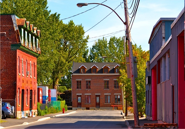
Leaving aside the fact that there were no citizens of any European state in 1814, this sounds remarkably familiar. This is the same critique I have written many times about Griffintown and Montreal: as Montreal gentrifies, it is becoming much like any other major North American city.
But it is also true of gentrification in general. There is a part on the North Shore of Chattanooga, Tennessee, I really like. It finally dawned on me that it is because it reminds of me Vancouver architecturally, culturally, aesthetically, and in the ways in which the water (in this case the Tennessee River, not False Creek) is used by the redevelopment of this historically downtrodden neighbourhood. But. I could also be dropped into pretty much any North American city and see similarities: Toronto, Vancouver, Montreal, New York, Boston, Seattle, Portland (Oregon), Cincinnati, Cleveland, Buffalo, Chicago, Atlanta, Nashville. These are all cities (amongst others) where I have seen the same tendencies.
And, obviously, one aspect of gentrification is the cleansing of the city of danger and vice. Just like Moscow was cleaned up in the aftermath of 1812.
Deindustrialisation in the Rural Heartland
September 22, 2014 § 8 Comments
The Macon County Fair in Decatur, Il, was cancelled this year. The fair has been a going concern for 158 years, but it also survives through funding from the state of Illinois. Illinois, of course, is a particularly cash-strapped state, which is saying something. It has the lowest bond rating from Moody’s of all 50 states of these United States of America. So funding for county fairs in Illinois has dropped drastically since the turn of the century, from $8.16 million to $5.07 million. Meanwhile, Macon County’s population has been in steady decline since the 1980s, falling from 131,375 to 109,278 today.
We were in Decatur last summer, in our drive across the continent to my sister’s wedding in Portland, OR. It was a pretty, but sleepy town in Central Illinois. It remains a central component of the industrial/agricultural heartland of the United States. It is also the birthplace of the Chicago Bears, the franchise known as the Decatur Staleys, after its original owner, a food-processing magnate.
But Decatur is in trouble, its population also in steady decline since the 1980s. And this decline is reflected in the trouble the Macon County Fair has encountered, as the organisation that puts on the fair is carrying a $300,000 debt, and its headquarters was damaged by heavy rains in July.
What is happening in Macon County is not unique, it is symptomatic of most rural areas in the United States (and Canada) today, as corporate farming becomes further and further entrenched, in the wake of deindustrialisation. Oportunities in these areas dry up, people are left with no choice but to move away, most of them to big cities, both in the MidWest, but also Chicago and coastal cities. Most Midwestern cities continue to grow, though St. Louis seems to be bucking this trend, its population in free-fall since the mid-20th century.
The story of deindustrialisation in North America is one that has been largely limited to big coastal cities, most notably in the northeast, and the so-called “Rust Belt” that stretches around the Great Lakes on both sides of the border (for an excellent treatment of deindustrialisation in the Rust Belt, check out Steve High’s book, Industrial Sunset). Left out of this story is the affect of deindustrialisation on the rural areas across the Heartland.
Research Note: The Pont Champlain
June 4, 2014 § Leave a comment
 Nearly every time I drive over the Pont Champlain, I turn my brain off, and don’t think about the crumbling infrastructure of the bridge, I don’t think about how far it is down to the St. Lawrence. I don’t think about how deep the river is. I don’t think about the litres of ink spilled in the Montreal newspapers, in both official languages, about the bridge. I don’t think about the fact that god-knows-how-many billion dollars are being spent to fix a bridge that needs replacing whilst the politicians in Ottawa and Quebec City continue to argue about how best to replace the bridge. I don’t really think the bridge is going to fall down, of course. But.
So it was a nice change of pace to be finishing off a chapter of The House of the Irish on the dissolution of Griffntown in the 1960s, and to come across documents I’ve collected from the Library and Archives Canada in Ottawa, as well as newspaper articles from The Star, The Gazette and La Presse from the late 1950s and early 1960s, when the Pont Champlain was first opened, and it was a marvel of engineering, and then the city and federal government built the Autoroute Bonaventure into the city in preparation for Expo ’67.
The optimism! The excitement about a new bridge connecting Montreal to the South Shore! The excitement about the Bonaventure, which “sweeps majestically into the city, the river on one side, the skyline in front,” to quote one article from The Star. Next time I cross the Champlain, I’ll try to think of that.
Changes in Griffintown, 2011-2014
February 6, 2014 § 1 Comment
I got an email from Dave Flavell the other day. I’ve known Dave for a few years; he contacted me awhile back for some help on a project he was doing on Griffintown. He was collecting oral histories of the community and its diaspora, with a view towards publishing a book. Last time we talked about it, he said the book was on its way to publication. This email contained photos of Griff, in particular of the Horse Palace on Ottawa street, taken in 2011, 2013, and 2014. The changes are stunning.
Griffintown Horse Palace, 2011. Photo courtesy of Dave Flavell
In the first photo, we look down Eleanor street at the Horse Palace, built in 1862, standing at the end of the block on Ottawa, surrounded by huge trees. Time was these were amongst the only trees in Griffintown a hundred years ago. The old St. Ann’s Kindergarten is on the left, now the headquarters of King’s Transfer, a moving company that’s been based in the neighbourhood for almost a century. It’s also where I conducted the majority of the oral history interviews for House of the Irish, thanks to the generosity of Bill O’Donell, the president of King’s. In this picture, the Horse Palace looks much as it has for the past thirty-forty years. But a closer look shows that it’s already under transformation. Leo Leonard, the legendary proprietor of the Horse Palace, and his wife Hugeuette, had already sold and moved to a retirement home. Leo, though, did not get much of an opportunity to enjoy retirement, he died in in July 2012 at the age of 87. Already, the building is under renovation, new windows have been put in on the second floor. But the actual stable, which is just out of sight, behind those moving trucks, was still in full working order.

Griffintown Horse Palace, 2013. Photo courtesy of Dave Flavell
The next picture was taken last year. From the exact same spot. Now the Horse Palace residence is dwarfed by an 8-story condo built next door and behind it, fronting on rue de la Montagne. This building was under construction in 2011, but had not yet risen to dwarf the Horse Palace. The Horse Palace building looks tiny and insignificant in the shadow of the condo, which stretches across at least three lots on de la Montagne.
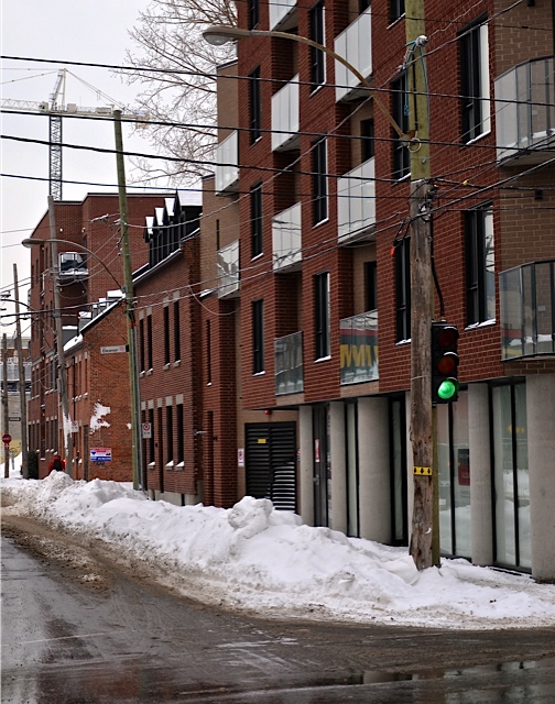
New condo tower and the Griffintown Horse Palace, January 2014. Photo courtesy of Dave Flavell
The final picture was taken a couple of weeks ago, from the corner of Ottawa and de la Montagne, looking east. The shop fronts on Ottawa in the new building remain empty, but looking down the block, after the Horse Palace residence is the old paddock of the stable, which was bought last year by the Ville de Montréal for purposes of turning it into a park to provide access to the actual stables, which the Griffintown Horse Palace Foundation has done yeoman’s work to preserve and save. (Full disclosure: I was a board member of the GHPF from 2008 until I left Montréal in 2012). Continuing on past the paddock, another mid-19th century residence still stands. And then, at the corner of Ottawa and Murray, another, shorter, 4-story condo stands. It was built in 2011. The crane is on the site of Devimco’s massive “District Griffin” development on Peel street.
Even though I have seen this view down Ottawa from de la Montagne, I was still shocked by Dave’s photo. The entire landscape of Griffintown is massively changed. The condo at the corner of de la Montagne and Ottawa is representative of the redevelopment. The streets of Griffintown are narrow, the buildings have always been hard up against the sidewalk. This has contributed to a somewhat claustrophobic atmosphere, at least on those blocks where enough buildings still remain. But these old buildings were 2 floors, at most 3. The stacking of 4, 6, 8, 10-story condos, lining these narrow streets only enhances this claustrophobia. It devastates the urban environment.
Genesis 1:28: Justification for Colonialism
January 17, 2014 § Leave a comment
I assigned William Cronon’s landmark Changes in the Land: Indians, Colonists, and the Ecology of New England this semester in American History. I read this the first a long, long time ago at the University of British Columbia during my undergrad. I read it again at Simon Fraser University during my MA studies. The book itself is 31 years old this year, but it was re-issued in a 20th anniversary edition in 2003. It is still a fantastic book, in my opinion.
But one thing struck me as I was reading. Cronon writes, concerning the English Crown’s attempts at taking possession of the land of New England:
The Crown derived its own claim to the region from several sources: Cabot’s “discovery” of New England in 1479-98; the failure of the Indians to adequately subdue the soil as Geneis 1.28 required; and from the King’s status — initially a decidedly speculative one — as the first Christian monarch to establish colonies there.
These are all points I am familiar with, obviously, after all those years of schooling and my teaching career. But sometimes, when I see the justification for early imperialism laid so bare as this, I am astounded. I won’t even get into the logical fallacies of relying on the Bible to justify the Crown’s claim to the land, possessed by non-Christians.
It gets better though, Cronon notes:
…by the late seventeenth century, Indian lands were regarded as being entirely within English colonial jurisdiction; indeed, the logic of the situation seemed to indicate that, for Indians to own land at all, it had first to be granted them by the English Crown.
Oy vey.
Urban Redevelopment: Getting it Wrong, Springfield, MA
October 27, 2013 § 3 Comments

City Hall Plaza, Boston
As regular readers of this blog know, I am interested in urban redevelopment, especially when it comes to questions of doing it right and doing it wrong (and chances at redemption). For the most part, the wave of urban redevelopment that hit North American cities in the 70s and 80s was the wrong way, in that it left us with neo-brutalist architecture in the midst of our cities that is cold, uninviting and intimidating. A case in point of this would be City Hall Plaza in Boston. It’s a desolate, soulless urban square that people use for one of three purposes: 1) official events, because they have no choice; 2) to sit on the fringes of to eat lunch; 3) to get to the Government Center T station. Many cities have this problem today, these horrid, horrid neo-brutalist buildings. In some places, like Boston, it doesn’t so much matter, because the downtown core of the city is bustling, Government Center lies between Faneuil Hall/Quincy Market and the stately Boston Common. Government Center is the site of, well, government in Boston and so this site is full of civil servants, but also tourists and Bostonians crossing between the tourist centres, the North End, and the downtown core of the city. In other places, like nearby Worcester, this 70s/80s wave of urban redevelopment led to a massive #fail.
But, the legacy of deindustrialisation is also very real, especially in small formerly urban centres, like Worcester, but also Springfield, Mass. Springfield is about 100 miles west of Boston and it feels about as faraway from Boston as one can get. Springfield is a depressed, sad little city. It has a high crime rate, nearly double that for the rest of the Commonwealth, including Boston. It’s murder rate, .13 per thousand, is almost triple the national average (perhaps unironically, Smith & Wesson’s corporate headquarters are in Springfield). The same is true for robbery and assault. Its property crime rates are also well above the national average.
It wasn’t always like this for Springfield. Until the 1960s, it was a bucolic industrial city, surrounded by natural beauty. It had a low crime and unemployment. It was the very first Springfield in the USA, and was the birthplace of basketball. Indian Motorcycles were from Springfield. So was Charles Goodyear. Merriam-Webster’s first dictionary was published there in 1805.

I-91, downtown Springfield and the Basketball Hall of Fame
Springfield experienced decline due to a combination of deindustrialisation, the closing of the Springfield Armory in 1969 (the target of Daniel Shays and his rebels in 1786), and poor urban development decisions (most notably the running of I-91 through the downtown core and cutting off downtown from the waterfront of the Connecticut River. Various attempts to redevelop the city have failed miserably (like the basketball Hall of Fame). And recently, the city decided that it was going to open a massive urban casino to flag the failing fortunes of Springfield. Why they thought this would work is beyond me. Certainly, people will now come to Springfield to shop and gamble. But, the casino will also siphon off jobs and hurt what business still exists in the downtown core. And now, even that appears to be at risk.
Rural Palimpsests: Amity, Missouri
October 24, 2013 § 9 Comments
 Amity is a blink-and-you-miss it tiny town on Route J in northwestern Missouri. The last census put its population at 54, though it has since shrunk to 47 (though, in the stupidity of American metropolitan areas, it is apart of the St. Joseph MO-KS Metropolitan Statistical Area, despite the fact that there is 30 miles of relatively empty farmland between St. Joseph and Amity). It looks, for all intents and purposes, like a dying town. Amity was founded in 1872, but when the Chicago and Rock Island Railway was completed in 1885, the townsite moved about a mile north to straddle the tracks. In its new location, Amity thrived, as general stores, hotels, banks, schools, and churches popped up as the town became an important stop on the railway. A stockyard for the Rock developed and the town became a waystation and loading zone for agricultural products from DeKalb County onto the railway. Similarly, consumer items were unloaded in Amity for the stores there and for DeKalb County in general. The town’s population rose to a high of 225 in the 1920s.
But Amity was a victim of circumstances, as it lived with the Rock, it also died with it. The Chicago Rock Island and Pacific (as it was eventually called) was a notoriously poorly-run and inefficient railway. By the 1970s, the gig was up. It had been run into the ground, and it pulled out of Amity in 1975. But the Rock (and Amity) were the victims of more than just poor management. Deindustrialisation was also central to the story here. As factories shut down in the major cities of the MidWest, from Chicago to Kansas City and beyond, the railways became increasingly less important to the heartland of the United States. And Amitysuffered. Even before the railway pulled out, the stores were suffering, the schools and churches were closing.

The former site of the Chicago Rock Island Pacific Railway through Amity
Today, Amity is barely hanging on. During our cross-country trip in August, we stayed with friends in Amity, Sam and Monica. To my city eyes, Amity was a piece of rural paradise. But Sam and I got talking about the history of the town. Sam is a native of Amity and Monica is from nearby Maysville. The longer we talked, the more fascinated with Amity’s past and present I became. I have written before on the changing rural landscape in North America (Hawley, Massachusetts, Phoenix, British Columbia, and Sainte-Sylvestre, Québec), but in talking with Sam I began to think about the costs of deindustrialisation in North America.

Abandoned home, Amity
Reams of work has been done on deindustrialisation in major cities (Buffalo, Cleveland, Chicago, Pittsburgh, Toronto, Hamilton), and my own work has looked at the cost of deindustrialisation on Griffintown, Montréal. But there was a real trickle-down effect at work here. The landscape of the MidWest (to say nothing of the rest of the continent) is cluttered with Amitys, places that were once important waystations on the railways, or homes to factories themselves (Monica’s mother worked at a Quaker Oats plant packaging instant oatmeal for two decades before it closed down). But their stories are in danger of being lost through little more than negligence.
As a culture, we don’t pay attention to these forgotten places, hell, we don’t even pay attention to the MidWest, at least outside of Chicago. For the life of me, I cannot call to mind a single TV show or movie set in a Midwestern city that’s not Chicago in the past quarter century. No wonder the people of the MidWest feel left out.

2nd Street, Amity, looking north towards where the railway used to be
But there is history here (I realise that sounds like a dead obvious statement) and the stories from places like Amity are important, as they speak to the human and cultural cost of deindustrialisation in the 1960s, 70s, and 80s just as much as those stories that arise out of Buffalo and Hamilton and Milwaukee. They place a human cost on the depopulation of rural areas of North America, and they place a cost on the loss of culture. The four of us (my wife, Margo, and I, Sam and Monica) are barely into our 40s, but we have lived through a series of cultural revolutions, from politics to technology. We are a transitional generation between the old ways of doing things and the (post)modern, post-industrial culture that we live in today. We remember rotary telephones and a world before the internet. Hard to imagine. But we’re also glued to our iPhones and lost without the internet when it goes down. Sam’s work as an artist seeks to preserve what he calls “obscure” technologies, printmaking and pottery. And I am an historian, my entire professional life is centred on the past. As a public historian, my work is centred on how we remember that past.
I am currently working on a research project that looks at the relationship between the far right of American politics and its relationship to history. But once that wraps up, hopefully in the next 6-8 months, I am going to begin work on my next project, which will be based on Amity and DeKalb County, looking at the cost of deindustrialisation on these rural spaces in the MidWest.
The Failure of Urban Redevelopment and the Chance at Redemption: Worcester
October 22, 2013 § 4 Comments
Worcester, Massachusetts, is like pretty much every city in New England not named Boston or Providence, and kinda like those Easter Bunnies I used to get when I was a kid: hollow centre. The downtowns of Hartford, New Haven, Springfield, Worcester, etc. were done in by deindustrialisation and horrid, horrid urban redevelopment schemes. The urban redevelopments schemes of the 70s, in hindsight, look as though they were especially created to destroy urban centres, not save them. Boston’s Government Center, for example, is one of the most hideous examples of neo-brutalist architecture I’ve ever seen.

Water/Fire, Providence, RI

Government Center, Boston
Worcester’s other problem is that it’s near Boston, less than an hour away. In fact, before I moved to Massachusetts, I thought Worcester was just a suburb of Boston. Boston is by far the biggest city in New England, over 5 times as big as the number 2 city, which just so happens to be Worcester (in fact, Worcester is the western boundary of the ridiculous Boston-Worcester-Manchester Combined Statistical Area). Worcester gets by, it is the home to several universities, including the University of Massachusetts Medical School, plus hospitals. But the downtown is a disaster.
City Hall Plaza, Boston
Worcester attempted and failed miserably to redesign its downtown in the 70s. It made sense at the time, as Paul McMorrow points out in today’s Boston Globe, the city erected a shopping mall downtown to counter the growth of suburban shopping malls. This was a common tactic. In some places, usually Canadian cities, this worked. Vancouver, Toronto, Montréal, Calgary, Ottawa all have shopping malls downtown. And in those cities, the malls are successful. Those are also very large cities, Ottawa is the smallest and its urban centre is still over 1 million people. It is worth noting, however, that I cannot think, off the top of my head, of a large American city with a successful shopping mall at its core. Boston has a small shopping concourse in the Prudential Center, but that’s it.
Nevertheless, the Worcester Center Galleria was a valiant effort. But it failed. Twice.

Worcester Center Galleria
The mall, when it was constructed, obliterated the street grid and landscape of downtown Worcester. But now, it’s been town down and the old street grid is being restored. The new CitySquare development is designed to do what most new urban redevelopments do: provide shopping, office space, and urban condos. All to convince a new, wealthy, demographic to move downtown, and stay downtown. McMorrow is hopeful for Worcester, as am I. And as Providence shows, urban redevelopment can be done and can be successful. But Worcester has the same problems as the rest of Massachusetts outside of Boston: the economy.
Immigration: The More Common North American Experience
September 6, 2013 § 4 Comments
The scenery as we drove across the United States and back was amazing. So were many of the place names. There is a town in Colorado named Rifle. Another town in Colorado is called Cahones. I kid you not. But perhaps my favourite highway road sign in all of the United States was this one we saw on the side of I-84 in Eastern Oregon.
 The sign pretty much says it all. Canadian and American culture is full of stories of the successful immigrant, the ones who came to these shores with nothing and made lives for themselves, who made fortunes and found fame. And while certainly there were a few who experienced this good fortune on North American shores, the majority did not. Most settled somewhere in between fame and fortune and poverty and despair.
Certainly, pop culture contains references to the downside of emigration. In Canada, university students in Canadian history and literature are tortured with perhaps one of the worst books in Christendom, Susanna Moodie’s interminable Roughing It In the Bush, Or, Life in Canada, about the trials and tribulations of Moodie and her husband, John Weddiburn Dunbar Moodie, a down-at-the-heels member of the British gentry, in the wilds of Upper Canada in the 1830s and 40s. While Moodie was a horrible writer and her husband an even worse poet, the book is a key text on the struggles of even wealthy emigrants in the British colonies in the mid-nineteenth century (it worked out ok for the Moodies, they ended up moderately wealthy and living in the thriving town of Belleville, Ontario).
One of my favourite Pogues songs is “Thousands Are Sailing,” which is the story of downtrodden Irish emigrants in New York City in the 19th century. The song is actually kind of heartbreaking.
So this sign for an exit on I-70 in Eastern Oregon struck me as a remarkable site. Old Emigrant Hill Road is on the northern side of I-70, and it runs into Poverty Flat Road on the southern side of the highway. Obviously, these two roads have been there for a lot longer than the Interstate. And, as you can see from the terrain surrounding the sign for the exit on the highway, the landscape around Poverty Flat Road isn’t exactly all that welcoming. This was also a common experience for emigrants to the “New World” in the 19th and 20th centuries: they ended up farming lands that were not conducive to growing much of anything. Generations struggled to make a living on these farms until someone, whether out of optimism or desperation, decided to clear off the land and make his or her fortunes elsewhere.
Perhaps this is the more common story of the immigrant in North America than the one of fame and fortune.
Wisdom On the Road
September 5, 2013 § 2 Comments
As you may have noticed, I took a bit of a hiatus from this site over the past month. We moved, then went on an epic road trip that saw us drive from our home near Boston to Portland, OR, for my sister’s wedding and back. Saw some amazing sites, met some really interesting people along the way.
Driving out of Portland through the Columbia Gorge was perhaps the most eventful part of the journey. My wife wanted nothing more than to swim in the Columbia River. So we stopped in Mayer State Park, about halfway between Hood River and The Dalles. Here we met a man named George. He was a retired trucker, spent thirty years driving the Seattle-Los Angeles run which had left him pretty much fed up with cities. Can’t say I blame him. So, he hit the road in his retirement. He was a 21st century hobo. He slept in his pickup truck and drove. His plates were from Washington state. Said he would drive down to Arizona for the winter. He headed into town now and then for a hot meal, check his email, get his Social Security. He carried with him a copy of the Good Book. George kind of reminded me of Buck 65’s character in his track, “Wicked and Weird.”
George was very excited about our road trip, said it would change our lives, it was good for our souls. I’m not sure I’d go that far, but it was good for our souls. Said that the problem with most people is that they get caught up in the moss, they get stuck. George is right, this is most of us, this is probably all of us. It’s hard not to get caught up in the moss, quite frankly. But that doesn’t make him any less right.
A chance encounter with a random guy in an Oregon state park parking lot. Perhaps the most memorable part of out trip.
